Get the most reliable climate data
Oops! Something went wrong while submitting the form.


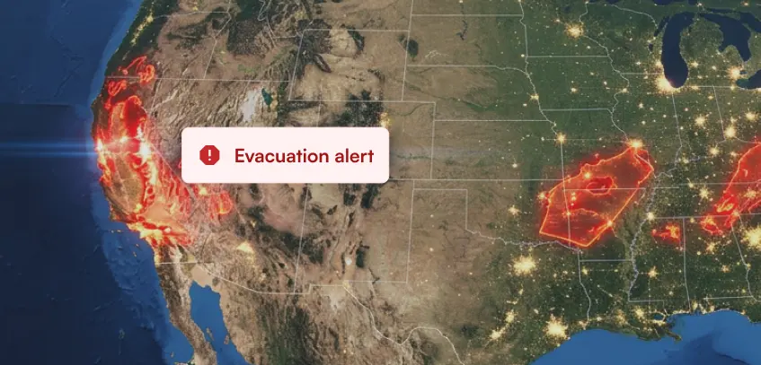
Wildfire data and predictive analytics are crucial for early fire detection and rapid response against the devastating effects of fires and climate change. Analyzing fire data from satellite sources and ground stations, like the system provided by Ambee, allows experts to identify fire-prone areas and predict fire behavior. This Ambee system, which refreshes fire locations every 5 minutes, allows authorities to swiftly allocate firefighting resources and optimize evacuation plans. Ambee leverages proprietary AI and ML algorithms to ensure the fire data is reliable and accurate.
{{key-insights}}
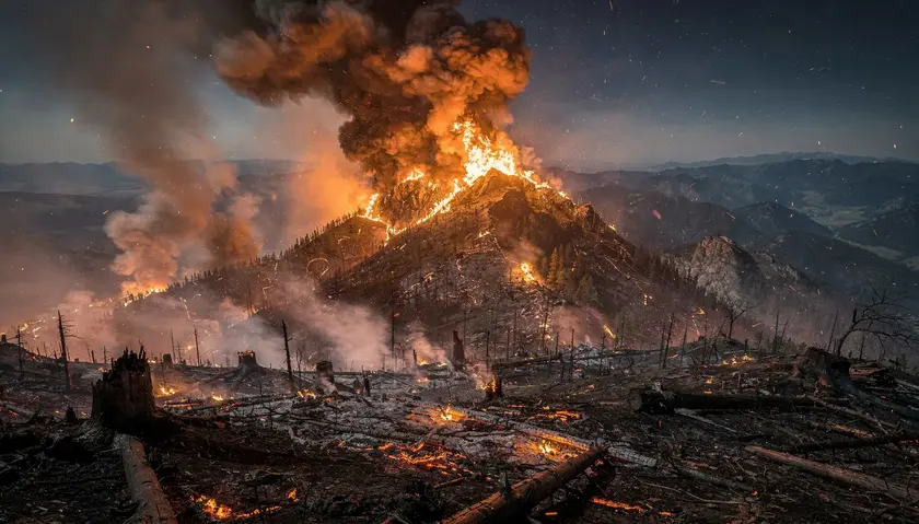
Fires, especially man-made and unchecked, have been devastating, causing significant damage to lives, properties, and the environment. Climate change has added significantly to this issue. Here are some of the statistics that may emphasize this:

Among other states in the US, California has had the most wildfires and the largest number of acres burned over the past five years. In California, wildfires burned 8.7 million acres from 2018 to 2022. Alaska had the second most wildfires, which burned nearly 6.5 million acres.

These instances showcase the importance of early fire detection systems and rapid response strategies. We believe that wildfire data can play a major role in assisting stakeholders in doing just that. Thanks to advancements in technology and the availability of fire data, it is now possible to leverage these resources for early fire detection and rapid response. Here are some of the applications of fire data for this cause.
Analyzing fire data enables experts to identify fire-prone areas, predict fire behavior, and detect fire incidents at an early stage. Sophisticated algorithms and machine learning techniques enable us to process large volumes of data and identify patterns indicative of potential fires. This early detection empowers emergency responders to intervene swiftly, preventing fires from escalating and spreading uncontrollably.
Satellites equipped with advanced imaging sensors act as a valuable resource for monitoring fires from space. These satellites can detect the presence of active fires, measure their intensity, and map their extent, especially in areas where manual intervention is impossible.
At Ambee, we combine and calibrate data from multiple sources, one of which is satellite data. We recently did a deep dive into GOES vs. Sentinel Satellite Band Channels. Read this blog to find out more about which satellite source we prefer to map burned areas of historical fires.
By integrating satellite imagery with other datasets, such as weather conditions, air quality reports, and land cover data, a comprehensive picture of fire risk and spread can be generated. This information aids in efficient resource allocation and enables fire agencies to plan targeted response strategies.
Added Geographic Information Systems(GIS) based risk models to this will help establish a relationship between vegetation, climate, and topography with wildfires. This will certainly help stakeholders calculate and map the probability of fire and its spread.
Fire data can be combined with historical records, weather forecasts, and geospatial information to develop predictive analytics models. Predictive analytics enables authorities to be better prepared and respond more effectively to various crisis situations. By leveraging advanced data, predictive analytics can help anticipate and forecast emergencies.
One example where data was used to predict fire risk and prioritize fire inspections was when the fire department in Atlanta, US, enlisted a local data science group to identify commercial properties missing from its fire inspections list.
They created Firebird, a big data tool, to identify buildings that are likely to have a fire hazard in the immediate future. Through an interactive map, Firebird integrated and visualized fire incidents, property information and inspections, and risk scores to inform the decision-making processes. Since implementation, it has been used to accurately predict fires 71% of commercial fires in Atlanta.
If a minor technological addition, such as Firebird, to traditional fire detection strategies can create such a huge impact, imagine the results if implemented on a larger scale.
Predictive analytics assess various variables such as weather conditions, vegetation density, and historical fire patterns to determine areas at high risk of ignition. By identifying these hotspots, authorities can:
By analyzing historical data, weather patterns, vegetation density, and topography, predictive analytics can pinpoint areas prone to wildfires. This information aids in developing evacuation plans that prioritize vulnerable communities and ensure timely evacuations.
Predictive models also consider real-time data, fire behavior, road networks, and population distribution to determine the most efficient evacuation routes and timing. This helps authorities avoid congestion and enables the safe evacuation of residents.
Predictive analytics can analyze historical wildfire data, fuel loads, weather conditions, and terrain to predict the potential intensity and spread of wildfires. This information assists in allocating firefighting resources, such as fire engines, aircraft, and personnel, to areas with the highest risk or greatest need.
These models can also estimate the demand for resources like fire retardants, water, and firefighting equipment. This enables agencies to strategically position and replenish supplies, ensuring efficient utilization during firefighting operations.
With the help of predictive analytics, stakeholders can develop early warning systems for wildfires. These systems provide timely alerts to authorities and communities, allowing them to take proactive measures such as implementing fire restrictions, initiating controlled burns, or issuing evacuation orders.
They can also simulate and predict the behavior and spread of wildfires to help anticipate fire movements, prioritize resources, and devise effective containment strategies.
Remote fire monitoring using fire maps is a crucial component of modern fire prevention and management strategies. Fire maps provide real-time information about the location, intensity, and spread of wildfires.
The primary advantage of remote fire monitoring is its ability to detect fires early, even in inaccessible regions. Satellite sensors, drones, or cameras can detect the presence of heat signatures, smoke plumes, and changes in vegetation cover, allowing authorities to identify potential fire outbreaks before they escalate into large-scale disasters.
In a recent study, a forest's fire risk was assessed using advanced data for early fire detection. The study focused on a pine forest in Thessaloniki, Greece, prone to wildfires. The system was evaluated using real and synthetic images converted to maps and achieved a high detection rate of 91.6% for real fires. This method shows promise for monitoring, protecting, and detecting suburban forest fires in Thessaloniki.
Such overlaying fire maps with information on air quality, weather conditions, and vulnerable areas, emergency responders can prioritize their efforts and make informed decisions on deploying firefighting teams, aircraft, and equipment.
These fire maps are updated in near real-time, providing a dynamic view of the evolving fire situation. This information can be shared with multiple stakeholders, including fire departments, land management agencies, and local communities, facilitating coordination and collaboration in fire suppression efforts.
Remote fire monitoring also aids in post-fire assessment and recovery. By comparing pre and post-fire imagery, researchers and land managers can evaluate the extent of damage, assess ecological impacts, and plan restoration activities. This information helps in understanding the long-term effects of wildfires and implementing strategies to reduce future fire risks.
At Ambee, we have near real-time detection of wildfires and monitoring. We look at multiple satellite data sources and ground station sources and combine them to give fire locations every 5 mins. Using geostationary satellites for any region makes the detection of fires quicker and more accurate.
Let me explain how
Geostationary satellites offer several advantages when it comes to fire hotspot detection and monitoring in any region. Those are:
However, the algorithm employed by polar-orbiting satellites to detect wildfires is different. They analyze the observed reflectance values to distinguish fire signals from background noise. They leverage the unique spectral signatures of fires in combination with contextual information.
And to remove false positives from their detections, they group adjacent pixels with high fire activity and consider spatial patterns to differentiate fires from other thermal anomalies, such as hot surfaces or industrial emissions.
Hence, using a combination of both satellite sources, along with government station reports, Ambee provides fire locations every 5 minutes. With added tech capabilities of our proprietary AI and ML algorithms and merging data from various types of satellites, we ensure our data is reliable and accurate without any false negatives.
Harnessing fire data for early fire detection and rapid response has immense potential to save lives, protect property, and minimize the devastating impact of fires. Ambee leverages the power of satellite imagery, IoT devices, artificial intelligence, and predictive analytics to provide the most accurate fire data. Using this, emergency responders can gain valuable insights into fire behavior, enabling proactive strategies and timely interventions.
Ambee’s forest fire API provides users with critical information on the location, intensity, and size, among other parameters. This also includes comprehensive air quality data that can help detect the lingering effects of toxic air. Some of our new parameters also include the Fire Risk Index and burnedArea polygon coordinates, which can be highly beneficial to analyze the burnt locations with greater depth. Ambee’s forest fire API is available globally and has an hourly refresh rate.
Read about Ambee’s enhanced fire API here. If you’d rather try it out yourself, sign up for our API dashboard.
Ambee also provides a product dedicated to forest fires. Get a complete picture of this tool and the intent behind its development in this blog: The Devastating Risks of Global Wildfires: How Can Technology Help?

Explore Ambee’s Fire Risk Analytics Tool for yourself!