Products /
Climate visualization
Every dataset Ambee builds is designed to be seen
Ambee Visualization delivers climate data in geospatial format as embeddable heatmap tile layers for any application
Ambee Visualization delivers climate data in geospatial format as embeddable heatmap tile layers for any application


Ambee Visualization delivers live environmental heatmaps that embed directly into any product. Built on proprietary infrastructure and compatible with every major mapping library, it puts real-time climate context exactly where decisions are made.
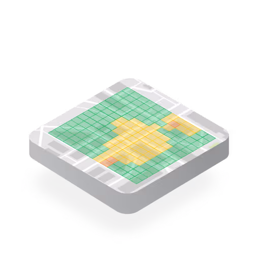
Air quality, temperature, and pollen conditions render as live visual layers inside any application.

Heatmap styling, color gradients, and layer behavior are fully configurable. Our proprietary infrastructure ensures the visualization adapts to any product and brand.

Layers reflect the most current available conditions, and recent historical data is accessible through the same integration.

Heatmaps scale seamlessly from regional overviews to street-level detail, with fast load times and 95.9% uptime reliability.
Ambee Visualization is compatible with Leaflet, Mapbox, Google Maps, OpenLayers, ESRI ArcGIS, and more mapping libraries.

Ambee Maps is a live, interactive visualization of the same climate intelligence delivered through Map Tiles. Pan across any location, switch between datasets, and move through time to understand exactly how air quality, pollen, wildfire, weather, and disaster data are changing.
A preview of Ambee Maps. Air quality shows as a colour-graded heatmap from green for good conditions to deep red for hazardous. Natural disaster and wildfire events appear as icons that expand into polygons as you zoom in. Hover for details and zoom in or out to navigate.

Embed air quality and pollen intelligence into health apps, HCP portals, and brand experiences.

Map wildfire perimeters, disaster events, and air quality across portfolios.

Layer climate conditions onto route planning and operations to see how weather and disaster events affect movement.

Surface hyperlocal climate data into property and site assessment tools, giving buyers, developers, and planners the context they need.

Monitor active wildfires, disaster events, and air quality across jurisdictions, with embeddable views to share across agencies.
Available for immediate integration into any product. Talk to the team to get access or see a walkthrough.