
Get the most reliable climate data
Oops! Something went wrong while submitting the form.


When it comes to disaster-related loss of life, even 24 hours can change outcomes. UN data shows mortality rates are at least six times lower in countries with effective early warning systems, and a single day of advance notice before a hazardous event can reduce damage by up to 30%.
The need for that small window is only growing. In 2025, the United States alone experienced 23 weather and climate disasters that each exceeded $1 billion in damage.
The U.S. Chamber of Commerce Foundation summarized the stakes clearly when they quoted: "Every $1 invested [in preparedness] returns $13 in economic benefits."
Agencies such as the National Oceanic and Atmospheric Administration issue timely weather alerts to help safeguard life and property. These alerts activate coordinated responses from organizations, including the Department of Health and Human Services Administration. Real-world data support the projection models behind these efforts, helping teams prepare communities, position first responders, and make decisions when minutes matter.
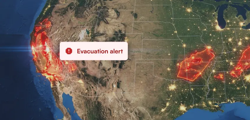
But as natural disasters become more frequent and more severe, the data supporting these responses must evolve as well. Many preparedness programs still do not incorporate the full range of available real-world data attributes. Those gaps affect planning accuracy across all 50 states and five U.S. territories and can leave the most vulnerable communities without the protection they need.
This is the gap Ambee and LexisNexis Risk Solutions are working to close. Together, they demonstrate how environmental intelligence and real-world demographic data can strengthen each other.
From what we have seen, there are three primary ways real-world environmental data is already reshaping disaster management. Here is a closer look.
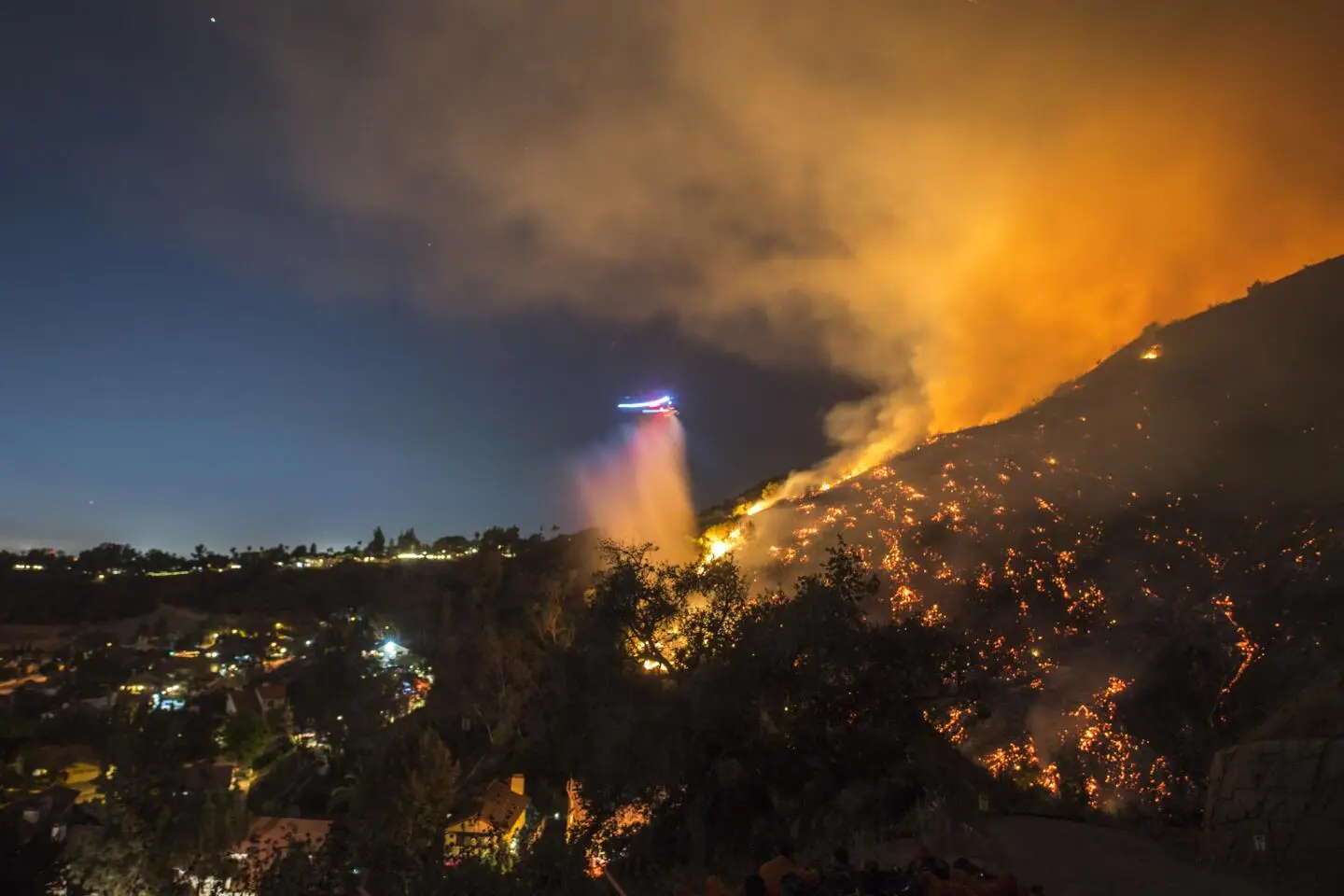
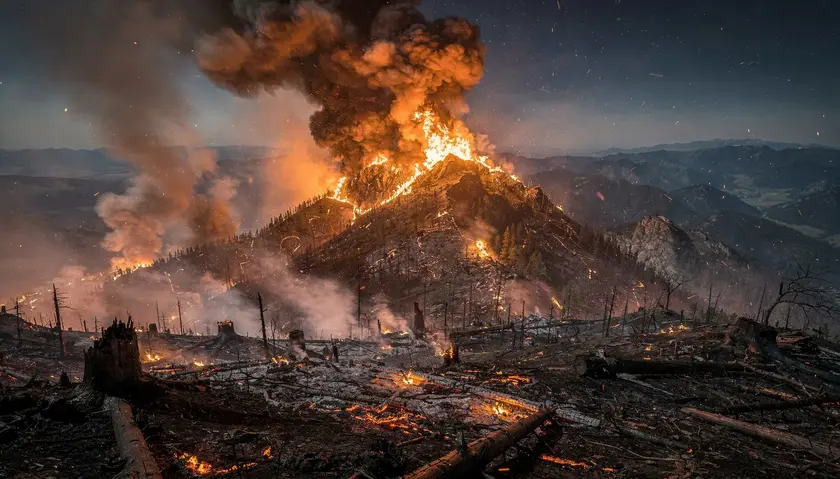
On the evening of January 7, 2025, a fire ignited in Eaton Canyon in the San Gabriel Mountains of California. Within 40 minutes, thousands of residents in eastern Altadena received a piercing alert on their phones: “LEAVE NOW.”
But just a few blocks west, evacuation orders for western Altadena were not issued until early the following morning, more than nine hours after the fire began.
17 people lost their lives in the wind-driven fire that swept across Lake Avenue. Many were elderly or had limited mobility. These are the very residents who need more time.
Several individuals later shared that they received no alert at all. Susan Lee Streets reflected on that night:
“If we had even been informed that houses and other structures were burning down, we would have known better what was happening. We almost went to sleep that night with two kids and a dog and two cats in the house.”
Moments like these reveal the limits of the alert systems currently in place. It isn't necessarily a lack of environmental signals. The difficulty lies in translating those signals into timely, hyperlocal action that reaches the right people, especially the most vulnerable.
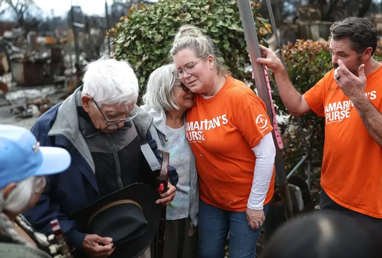
The total cost of the January 2025 Los Angeles wildfires is estimated between $76 billion and $131 billion. Behind those figures are homes, communities, and lives that cannot be measured in dollars alone.
This is the gap the Ambee and LexisNexis Risk Solutions collaboration is working to close. Ambee’s wildfire forecasting models operate with up to 30-day lead times and over 85% accuracy, identifying high-risk zones before traditional alerts like NOAA alerts or satellite detection.
Wildfires have claimed lives and caused devastation throughout history. What makes this moment different is that the technology to anticipate and mitigate many of these outcomes now exists.
📖 Also Read: Meet Ambee’s wildfire risk forecast
The victims of the Eaton fire had a median age of 77. At least a third were living with limited mobility.
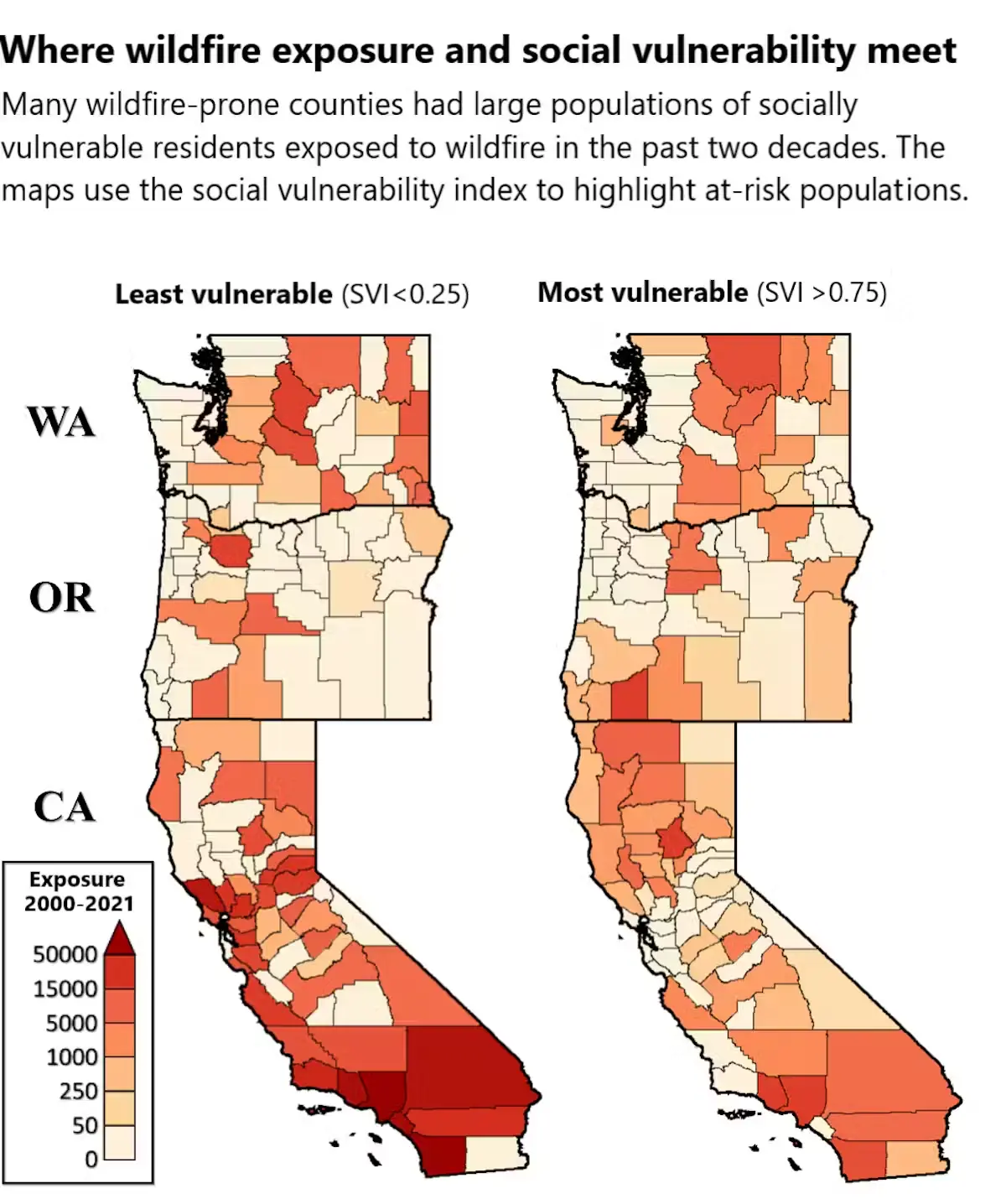
According to the USDA Economic Research Service, 87% of recent population growth in moderate to high wildfire risk areas has been among adults over the age of 60.
States with some of the highest concentrations of older adults living in high-risk wildfire zones include California, Florida, and Texas. These are also among the most disaster-prone states in the country.
The Conversation has an entire article discussing at length how wildfire risk increasingly overlaps with low-income elderly communities across California, Washington, and Oregon. These are individuals who may already face financial strain, limited access to healthcare, and housing vulnerability. Add wildfire to that equation, and recovery becomes far more difficult.
Reduced mobility, reliance on medical devices, and cognitive decline already slow down evacuation significantly. To most alert systems, a neighborhood is a single, uniform entity. A wireless emergency alert is sent to everyone within a defined geographic boundary.
The same message sent through the same channel doesn't check who lives behind those doors.
Residents who do not speak English may not fully understand evacuation instructions. Individuals without access to a personal vehicle may have no way to act on them, even if they do.
This is why layering demographic and identity data on top of environmental forecasts is undeniably essential.
LexisNexis Risk Solutions aggregates insights from more than 10,000 public and proprietary sources, covering nearly the entire U.S. adult population with 99.99 percent accuracy, and has provided these datasets to over 9,500 federal, state, and local agencies.
When this level of demographic intelligence is integrated with forward-looking environmental forecasts, agencies can move toward more precise, household-level outreach.
That granularity determines who receives a phone call instead of a text. Who is then flagged for an in-person welfare check.
Knowing a wildfire is likely 30 days out only matters if that intelligence leads to action.
Here is what that chain looks like when the right data is connected from the beginning:
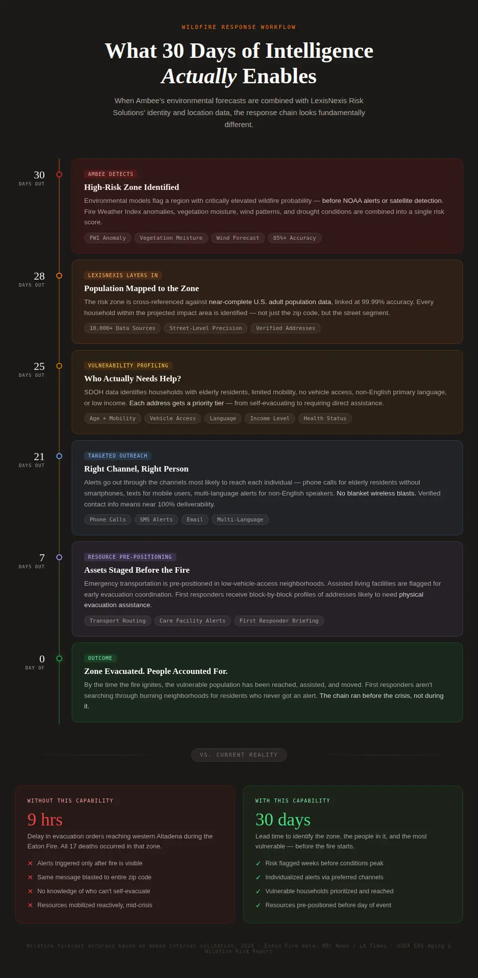
The contrast at the end of that sequence says everything. Nine hours versus thirty days represents two entirely different categories of response. One begins after danger is visible. The other begins while there is still time to protect people.
At its core, disaster preparedness is a sequence of decisions that must happen in the right order and early enough to matter:
Environmental signal detected → Risk zone projected → Vulnerable residents identified → Outreach personalized → Resources pre-positioned → Evacuation assisted
Each link in that chain already exists. What has been missing is the ability to run it as a single, coordinated workflow, triggered weeks before conditions become critical.
The Ambee and LexisNexis Risk Solutions collaboration focuses on connecting environmental intelligence with real-world demographic context so this chain actually works. The full approach is outlined in the white paper, which you can read here.
If you would like to explore the environmental intelligence component directly, Ambee’s Wildfire Forecast API provides daily updated wildfire risk outlooks up to four weeks in advance, designed to support operational planning rather than reactive response.
🔗 Explore Ambee's Wildfire Forecast API


![Best flood data providers in 2026 [Complete list & comparison]](https://cdn.prod.website-files.com/6281f31808e2aa515581d87e/697b512bf5c04ca781af12e9_flood-data-providers.webp)